
DES MOINES, Iowa—Iowa Secretary of Agriculture Mike Naig commented on the Iowa Crop Progress and Condition Report released by the USDA National Agricultural Statistics Service. The report is released weekly April through November. Additionally, the Iowa Department of Agriculture and Land Stewardship provides a weather summary each week during this time.
“With this year’s strong harvest nearly complete and the snow beginning to fly, Iowa farmers are looking ahead to next year by considering input choices, conservation practices and marketing decisions,” said Secretary Naig. “Following three consecutive La Nina winters, this winter is expected to be impacted by a moderate to strong El Nino, which typically means warmer temperatures and more variability in precipitation. As we head into the 2024 growing season, replenishing soil moisture will be of utmost importance.”
The weekly report is also available on the USDA’s website at nass.usda.gov. This is the final Crop Progress and Condition Report of the season. Reports will resume in April 2024.
Crop Report
A relatively dry week with snow falling at the weekend resulted in 6.1 days suitable for fieldwork during the week ending November 26, 2023, according to the USDA, National Agricultural Statistics Service. Fieldwork activities started to slow down this week with reports of fertilizer and manure application wrapping up.
Topsoil moisture condition rated 22 percent very short, 45 percent short, 33 percent adequate and 0 percent surplus. Subsoil moisture condition rated 33 percent very short, 40 percent short, 26 percent adequate and 1 percent surplus.
Corn harvested for grain is virtually complete with farmers in the southern part of the State still running a few combines, 9 days ahead of the 5-year average.
Cattle grazing on stalk fields continued this week, while no reports were received regarding livestock conditions.
Weather Summary
Provided by Justin Glisan, Ph.D., State Climatologist, Iowa Department of Agriculture and Land Stewardship
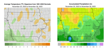
Unseasonably warm temperatures early in the reporting period were balanced out by a late-week cold snap that brought measurable snow across most of Iowa. Overall temperatures were generally near normal with the statewide average coming in at 31.9 degrees, 0.6 degree below normal. Several disturbances brought measurable precipitation, both rain and snow, to most of Iowa’s stations. Northwestern Iowa missed out on higher totals, receiving under 25 percent of normal weekly precipitation.
Light showers moved into western Iowa on Sunday (19th) afternoon as a large low-pressure center propagated from Oklahoma through Missouri. Winds shifted to an easterly direction as cloud cover increased with daytime temperatures in the upper 40s and low 50s. Rainy conditions continued through Monday (20th) as the disturbance pushed into Illinois with moderate showers spinning into eastern Iowa on the backside of the low. Event rain totals were highest in the state’s southwest and southeast corners as many northwestern stations missed out on measurable amounts. More than one-third of Iowa’s stations reported between 0.20 to 0.45 inch; Pacific Junction (Mills County) registered 0.51 inch while 0.60 inch was reported in Clarinda (Page County). Afternoon temperatures remained in the mid-40s as winds turned to the northeast. Overnight lows into Tuesday (21st) dropped into the low 30s northwest as a cold front swept southeast with winds shifting northwesterly. Cloudy conditions remained over eastern Iowa as wind speeds increased across the Upper Midwest; daytime highs varied from the low to mid 40s west to east, depending on where sunshine prevailed. Starry skies persisted into Wednesday (22nd) morning as temperatures dropped into the upper teens and low 20s. Afternoon temperatures rebounded under sunny conditions and strong southwesterly winds; stations in western Iowa observed highs approaching 60 degrees while temperatures on the eastern side were 15 to 20 degrees cooler.
A weak, fast-moving cold front moved through Iowa before daybreak on Thursday (23rd) with morning temperatures ranging from the mid-20s northwest to mid-30s southeast under cloudless skies. Blustery winds out of the north held daytime temperatures in the low 30s to low 40s north to south as sunny skies persisted. Single-digit temperatures were observed across northern Iowa on Friday (24th) with negative departures approaching 12 degrees; temperatures were in the 20s across the south with a statewide average low of 19 degrees, five degrees below normal. Cloud cover increased in southwestern Iowa as temperatures climbed into the upper 20s and low 30s. Iowans woke up to overcast skies and snowflakes in western Iowa on Saturday (25th) as another low-pressure center moved across the region. Snow showers spread over the state into the evening hours and continued overnight into Sunday (26th). Snow totals were highest in south-central and eastern Iowa while widespread one- to two-inch amounts were observed over Iowa’s southeastern two-thirds; Cedar Rapids (Linn County) measured 3.7 inches while Osceola (Clarke County) hit 4.0 inches. Low temperatures hovered in the mid to upper 20s over much of the state with upper teens in the southwest.
Weekly precipitation totals ranged from no accumulation at a few northwestern stations to 0.85 inch in Clarinda. The statewide weekly average precipitation was 0.33 inch, while the normal is 0.41 inch. Lamoni (Decatur County) reported the week’s high temperature of 63 degrees on the 19th, 14 degrees above normal. Estherville (Emmet County), Mason City Municipal Airport (Cerro Gordo County) and Swea City (Kossuth County) reported the week’s low temperature of nine degrees on the 24th, on average 11 degrees below normal.
(contributed press release, IDALS)