
DES MOINES, Iowa—Iowa Secretary of Agriculture Mike Naig commented on the Iowa Crop Progress and Condition Report released by the USDA National Agricultural Statistics Service. The report is released weekly April through November. Additionally, the Iowa Department of Agriculture and Land Stewardship provides a weather summary each week during this time.
“Widespread rain fell across Iowa over several days last week and a cold blast brought the first measurable snow to northern Iowa,” said Secretary Naig. “The weather forecast looks drier over the next week with temperatures slowly climbing to near seasonal, offering farmers an excellent window to harvest or complete other field work.”
The weekly report is also available on the USDA’s website at nass.usda.gov.
Crop Report
Moderate rainfall during the week slowed harvest in some areas as Iowa’s farmers had an average of 4.2 days suitable for fieldwork during the week ending October 29, 2023, according to the USDA, National Agricultural Statistics Service. Fieldwork included harvesting row crops, completing fall tillage, applying fall fertilizer, baling stalks, and hauling manure.
Topsoil moisture condition rated 12 percent very short, 35 percent short, 51 percent adequate and 2 percent surplus. Subsoil moisture condition rated 25 percent very short, 42 percent short, 31 percent adequate and 2 percent surplus.
Corn harvested for grain reached 77 percent statewide, 1 day ahead of last year and 8 days ahead of the 5-year average. Moisture content of field corn being harvested for grain remained steady at 17 percent. Soybeans harvested reached 93 percent, on pace with last year but 8 days ahead of the average.
Pasture condition improved slightly to 20 percent good to excellent. Livestock conditions were reported as generally good but getting water to pastured cattle continued to be an issue for some producers.
Weather Summary
Provided by Justin Glisan, Ph.D., State Climatologist, Iowa Department of Agriculture and Land Stewardship
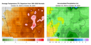
Several weather disturbances brought widespread rains and the first measurable snow across northwest Iowa late in the reporting period; much of Iowa received above-average precipitation. Unseasonable warmth persisted until a Canadian airmass ushered in winter-like temperatures over the weekend; the statewide average was 53.0 degrees, 6.7 degrees above normal.
Sunny skies and southerly winds helped boost Sunday (22nd) afternoon temperatures into the mid-60s west while stations in eastern Iowa remained in the upper 50s. Showers pushed into western Iowa through the evening with additional thundershowers forming across northern Iowa into Monday (23rd) morning. Many north-central stations reported amounts between 0.25-0.75 inch with widespread totals over the state’s northern half in the 0.10-0.25-inch range. Clouds cleared through the late morning as daytime highs rose into the upper 70s with low 80s observed in central Iowa; the statewide average high was 76 degrees, 17 degrees above normal. Isolated strong storms fired in northwestern Iowa just before midnight, leaving behind 1.00-inch hail and 0.34 inch of rain in Spencer (Clay County). Showers streamed into southern and eastern Iowa through Tuesday (24th) ahead of a low-pressure center moving towards the state. Skies were partly to mostly cloudy with afternoon temperatures in the 70s with a strong southerly wind. Pockets of rainfall persisted in eastern Iowa overnight into Wednesday (25th) as lows ranged from the mid-50s north to low 60s south. Widespread totals of around 0.10 inch were reported with several north-central and southeast stations registering totals in the 0.50-1.00-inch range; Burt (Kossuth County) hit 0.60 inch with 1.32 inches near Keokuk (Lee County). Afternoon conditions remained overcast with highs in the low to mid-60s. Showers across northern Missouri pushed into Iowa’s southeast half through the evening hours and continued overnight into Thursday (26th) with lows mirroring daytime highs.
Showers and some thunderstorms held on over eastern Iowa into the late evening with additional cells forming as the low-pressure center and cold front propagated east. Strong northwesterly winds developed behind the front with quite the spread of morning temperatures; mid to upper 60s were registered southeast to low 30s northwest. Rain totals for the previous 48 hours reported at 7:00 am on Friday (27th) highlighted more than 120 stations observing at least 1.00 inch with heavier totals in eastern Iowa; an observer in Cedar Rapids (Linn County) reported 2.02 inches with a 2.45-inch total in Monticello (Jones County) and a statewide average of 0.83 inch. Gusty northwesterly winds held on through the day with clouds clearing western Iowa late in the day. High temperatures were 10-20 degrees below normal with mid-30s west to mid-40s east. Overcast skies continued into Saturday (28th) morning as moderate snow showers pushed into northwestern Iowa before daybreak. Light snow and flurries continued over portions of northern Iowa through much of the day; measurable snow was observed at 34 stations and varied from trace amounts to 4.0 inches at Cherokee (Cherokee County), Sioux City (Woodbury County) and Spencer. Afternoon conditions were cloudy and cold with upper 20s in northern Iowa and several low 40 degree-readings in the southeast; the statewide average high was 37 degrees, 18 degrees below normal. Overnight lows into Sunday (29th) did not drop appreciably as northerly winds remained.
Weekly precipitation totals ranged from 0.04 inch at Pacific Junction (Mills County) to 2.64 inches in Monticello. The statewide weekly average precipitation was 1.00 inch, more than double the normal of 0.48 inch. Several stations reported the week’s high temperature of 83 degrees on the 24th, on average 23 degrees above normal. Several northwestern stations reported the week’s low temperature of 22 degrees on the 28th and 29th, on average nine degrees below normal.
(contributed press release, IDALS)