
DES MOINES, Iowa—Iowa Secretary of Agriculture Mike Naig commented on the Iowa Crop Progress and Condition Report released by the USDA National Agricultural Statistics Service. The report is released weekly April through November. Additionally, the Iowa Department of Agriculture and Land Stewardship provides a weather summary each week during this time.
“While the highest rainfall totals were concentrated in western Iowa over the past week, much of the state received some rain and cooler temperatures,” said Secretary Naig. “The crops could use some heat, and it looks like it’s on the way. The warmer weather and possible showers in the forecast this week should give the corn and soybeans a lift.”
The weekly report is also available on the USDA’s website at nass.usda.gov.
Crop Report
Iowa farmers had 4.7 days suitable for fieldwork during the week ending June 8, 2025, according to the USDA, National Agricultural Statistics Service. Field activities included cutting hay and spraying crops.
Topsoil moisture condition rated 4 percent very short, 21 percent short, 71 percent adequate and 4 percent surplus. Subsoil moisture condition rated 5 percent very short, 28 percent short, 64 percent adequate and 3 percent surplus.
Corn emerged reached 92 percent, 4 days ahead of last year’s pace but 2 days behind normal. Corn condition rated 85 percent good to excellent, up 1 percentage point from last week. Ninety-seven percent of the expected soybean crop has been planted with 88 percent emerged. Soybean emergence was 10 days ahead of last year and 4 days ahead of normal. Soybean condition rated 80 percent good to excellent, down 1 percentage point from last week. Emergence of the oat crop is nearly complete, with 53 percent headed and 10 percent turning color. Oat condition rated 84 percent good to excellent.
Seventy-seven percent of the State’s first cutting of alfalfa hay has been completed and there were scattered reports of farmers starting the second cutting. Hay condition rated 82 percent good to excellent. Pasture condition decreased slightly to 70 percent good to excellent.
Weather Summary
Provided by Justin Glisan, Ph.D., State Climatologist, Iowa Department of Agriculture and Land Stewardship
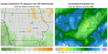
Several rounds of showers and thunderstorms brought widespread rainfall over the state with above-average amounts in western Iowa; east-central Iowa reported 0.50-1.00 inch deficits. Temperatures were near-normal to slightly cooler for much of Iowa through June’s first week with a statewide average temperature of 66.3 degrees, 0.9 degrees below normal.
Sunday (1st) afternoon was sunny with wildfire haze persisting as temperatures varied from the upper 70s east to mid 80s west. Southerly winds developed into Monday (2nd) with clear skies at sunrise and unseasonably warm morning temperatures in the upper 50s and low 60s. Afternoon temperatures rose into the upper 80s and low 90s as wind speeds increased out of the south ahead of a cold front draped across the Dakotas; the statewide average high was 87 degrees, 10 degrees above normal. The surface boundary pushed into western Iowa into the evening hours with initial, isolated severe-warned thunderstorms firing from the afternoon heat. Wind damage to a hog barn was reported in Hospers (Sioux County) from a localized downburst along with heavy downpours. Scattered showers and thunderstorms expanded across western Iowa overnight into Tuesday (3rd) and spread into eastern Iowa through the daytime hours. With rain and overcast skies, afternoon temperatures held in the upper 50s behind the front while upper 70s were observed in eastern Iowa, where atmospheric instability was present. Severe thunderstorms developed along the cold front and spawned an EF-0 tornado in New Boston (Lee County) and an EF-1 tornado south of the Quad Cities.
The system exited the state by daybreak on Wednesday (4th) with widespread rainfall totals reported at 7:00 am. Nearly 30 stations registered at least 2.00 inches with the highest amounts found in northwest and eastern Iowa; Le Claire Lock and Dam (Scott County) collected 2.01 inches while Sioux Center (Sioux County) hit 3.73 inches. Much of east-central Iowa observed totals in the 0.25-0.50 inch range; the statewide average amount was 0.94 inch. Calm to light winds and clear skies allowed foggy conditions to develop on Thursday (5th) morning with temperatures from the mid 40s west to upper 50s east. Winds swung around to the northeast as afternoon conditions warmed into the 70s with mostly sunny skies. Showers moved into western Iowa later in the day and propagated through northern Iowa into Friday (6th) morning. Rain amounts were under a few tenths of an inch over the state’s northwestern half. Skies remained partly cloudy with light winds and temperatures in the 70s. Spotty showers redeveloped across north-central Iowa on Saturday (7th) morning with the highest totals ranging from 0.61 inch at Mason City Municipal Airport (Cerro Gordo County) to 0.74 inch in Ames (Story County). A more concentrated complex of moderate showers moved along the Iowa-Missouri border and into central Iowa through the day with several stations collecting more than an inch; Perry (Dallas County) observed 1.18 inches while Jefferson (Greene County) picked up 1.63 inches. Conditions cleared into Sunday (8th) as a cold front dropped southeast across Iowa with temperatures hovering in the upper 50s and low 60s.
Weekly precipitation totals ranged from 0.13 inch at Waterloo Municipal Airport (Black Hawk County) to 3.86 inches in Sioux Center. The statewide weekly average precipitation was 1.26 inches; the normal is 1.17 inches. Sioux City Airport (Woodbury County) reported the week’s high temperature of 94 degrees on the 2nd, 15 degrees above normal. Several stations reported the week’s low temperature of 44 degrees on the 4th, on average 12 degrees below normal.
(contributed press release, IDALS)