
DES MOINES, Iowa—Iowa Secretary of Agriculture Mike Naig commented on the Iowa Crop Progress and Condition Report released by the USDA National Agricultural Statistics Service. The report is released weekly April through November. Additionally, the Iowa Department of Agriculture and Land Stewardship provides a weather summary each week during this time.
“Iowa farmers made significant progress in the field last week thanks to several consecutive days of warm and windy weather conditions,” said Secretary Naig. “This week’s forecast calls for cooler temperatures and several chances of rain showers, which may cause farmers to pause field work for a few days. We need the moisture across the state, and the widespread rainfall will give the recently planted corn and soybeans a good boost.”
The weekly report is also available on the USDA’s website at nass.usda.gov.
Crop Report
Little or no precipitation and warm temperatures allowed Iowa farmers 6.6 days suitable for fieldwork during the week ending May 18, 2025, according to the USDA, National Agricultural Statistics Service. Corn and soybean planting made rapid progress. There were scattered reports of replanting as early planted crops in some areas had struggled to emerge with the dry conditions.
Topsoil moisture condition rated 8 percent very short, 37 percent short, 53 percent adequate and 2 percent surplus. Subsoil moisture condition rated 6 percent very short, 34 percent short, 58 percent adequate and 2 percent surplus.
Corn planted reached 91 percent complete, 12 days ahead of last year and 4 days ahead of the 5-year average. Fifty-eight percent of corn had emerged, 5 days ahead of last year’s pace and 3 days ahead of normal. Eighty-four percent of the expected soybean crop has been planted just over 2 weeks ahead of last year and 1 week ahead the 5-year average. Soybeans emerged reached 42 percent, 8 days ahead of last year and 6 days ahead of normal. Eighty-six percent of the State’s oat crop has emerged. Oats headed reached 15 percent. Oat condition rated 0 percent very poor, 1 percent poor, 13 percent fair, 71 percent good and 15 percent excellent.
Twenty-three percent of the State’s first cutting of alfalfa hay has been completed. Hay condition rated 78 percent good to excellent.
Weather Summary
Provided by Justin Glisan, Ph.D., State Climatologist, Iowa Department of Agriculture and Land Stewardship
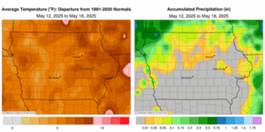
Much of southern and eastern Iowa reported rain-free conditions with departures approaching 1.20 – 1.40 inches below normal through the reporting period. Only stations in northwest Iowa received more than a few tenths of an inch. Unseasonably warm temperatures also persisted with a statewide average temperature of 65.0 degrees, 4.1 degrees above normal.
Sunday (11th) afternoon temperatures were in the upper 80s and low 90s northwest while upper 70s were observed southeast under sunny skies. Winds turned east to east-southeasterly on Monday (12th) morning with low temperatures in the 50s. Daytime temperatures rose into the 80s with low relative humidity and sunshine. Very isolated showers clipped the Iowa-Illinois border just after midnight, bringing meager totals to a handful of stations; Park View (Scott County) collected 0.01 inch while Camanche (Clinton County) registered 0.08 inch. Tuesday (13th) dawned with morning temperatures in the upper 50s and low 60s with mostly sunny skies. Afternoon temperatures warmed into the 80s with winds out of a southerly direction and spotty clouds in northeastern Iowa, where light showers popped up. Several stations reported minor amounts, ranging from 0.03 inch in Waukon (Allamakee County) to 0.31 inch in Ionia (Chickasaw County). Wednesday (14th) was mirror-image in terms of temperature and wind behavior with cloud cover increasing towards the end of the day as a low pressure center moved into South Dakota.
A line of stronger thunderstorms pushed across the northwest corner of Iowa overnight into Thursday (15th). Rain totals were locally heavy with 0.55 inch in Rock Rapids (Lyon County) to 0.77 inch in Sibley (Osceola County). Winds gradually shifted easterly through the day as a cold front swept west to east. Temperatures varied from low 60s northwest, behind the front, to upper 80s southeast. Winds swung back to the southwest by Friday (16th) with clear morning conditions and temperatures in the mid 50s to low 60s. Several lines of light showers ushered through the state’s northern half with many stations collecting less than 0.10 inch; Sibley observed an additional 0.29 inch with 0.14 inch at Le Mars (Plymouth County) and Orange City (Sioux County). The pattern quieted down into Saturday (17th) with a somewhat damp and chilly start to the day as temperatures held in the 40s with gusty northwesterly winds. Skies cleared from west to east in the afternoon with upper 50s and low 60s statewide. Clouds increased into Sunday (18th) morning over portions of northern Iowa with lows in the 30s to mid 40s.
Weekly rain totals ranged from no accumulation south and east to 1.06 inches in Sibley. The statewide weekly average rainfall was 0.05 inch; the normal is 1.01 inch. Davenport Municipal Airport (Scott County) reported the week’s high temperature of 94 degrees on the 15th, 22 degrees above normal. Mason City (Cerro Gordo County) reported the week’s low temperature of 32 degrees on the 18th, 16 degrees below normal. Soil temperatures were in the upper 50s to low 60s statewide as of Sunday.
(contributed press release, IDALS)